IMPORTANT UPDATE FROM THE EMERGENCY MANAGER
Kure Beach Citizens,
I hope this finds you safe and well. Changes to yesterday’s message are in BOLD.
Below is the update from the National Weather Service at 5:00 am today regarding Tropical Storm Debby. Town preparations will continue through Monday and Tuesday, and you should be wrapping up inspecting your yard and securing any items to prevent impacting your property or your neighbors with the possibility of Tropical Storm winds Wednesday evening. Also please ensure that you have no debris that could be washed by the projected heavy rains into the stormwater system causing a local area backup with 8-16" of rain forecast for the area during this event, localized flooding is possible.
The normal bulk trash pickups on Thursday morning of piled debris WILL NOT occur to allow Public Works to focus on Stormwater drainage throughout this event.
The Recreation Department has cancelled all outdoor programs through Thursday due to the weather.
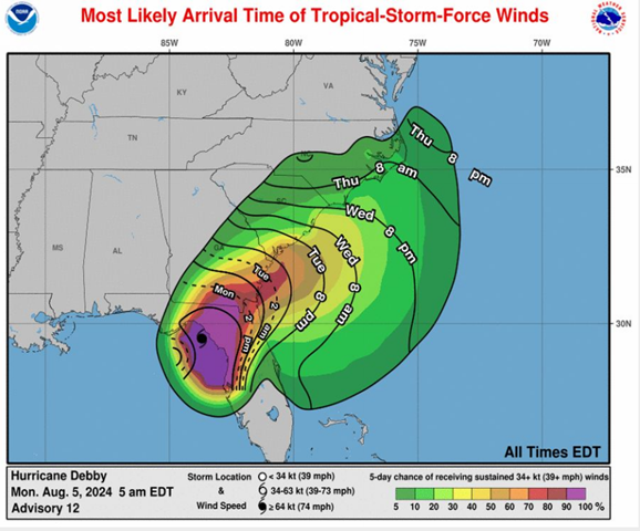
The track has seen little to no change since last update, however Debby is continuing to slow its forward speed. Any slow can delay and prolong impacts, particularly flooding. Debby is currently making landfall in the area of Big Bend FL as a Cat 1 Hurricane. Still forecasted to progress North and East across Georgia and exit to the Atlantic just South of Savannah Tuesday around 2pm. Once it enters the Atlantic its forward speed is projected to slow to a crawl of 2 - 4 mph. It is expected to make a northern turn sometime Wednesday and make a second landfall Northeast of Charleston SC Thursday afternoon, then a slow progression north-northeast. Intensity models show a slight strengthening while over the Atlantic but staying tropical storm strength. Any further reductions in speed, or time spent over the Atlantic, could increase cumulative rainfall totals for our area, current predictions are 8"-16" for our area.
Key Points from NWS
- Debby is expected to cross northern Florida today and move near the Georgia/South Carolina coast during Tuesday. The storm will move very slowly near the South Carolina coast Wednesday and Thursday before moving northward.
- The very slow progression of the storm could result in catastrophic amounts of rainfall across northeastern South Carolina and southeastern North Carolina, which would result in life-threatening flash flooding. Otherwise, gusty winds, some surge, and a few tornadoes are also possible - but it is too early to predict these specific impacts with detail given the uncertainty in the track beyond Wednesday.
- All interests in the Carolinas, and marine interests across the coastal waters, should continue to prepare for this evolving weather situation.
The Town has tested all generators and they are prepared in the event of a loss of power. Public Works, Fire and Police will respond to any issues and if you observe a stormwater backup all calls will be directed to public works at 910-458-5816. The answering service will be transferring calls after hours to on call phone in which we will respond to in the order they come in.
If you see downed power or cable lines treat them as energized and contact 911. Fire and Police will respond to evaluate safety issues and work to get the appropriate utility to clear them.
If the Town loses power please minimize your usage of water as with the Town full of residents and visitors, the lift station generators will be taxed to keep up. If you use temporary generators at your home ensure that there is proper ventilation generators (Carbon Monoxide poisoning) and chainsaws (following the storm) result in a significant number of deaths and injuries attributed to Hurricanes.
During the storm, please be careful and plan ahead for your trips. With these winds local conditions could become hazardous. Be extremely cautious of ponding water on roadways. Do not drive through standing water as you vehicle could become immobilized and then cause a traffic hazard impacting emergency services. Additionally a reminder that in the loss of power, or a non-functioning stop light all stop light intersections become 4 way stops.
Respectfully,
David W. Heglar, PE
Emergency Manager, Town of Kure Beach